Vision utilises laser scanning technology alongside other data capture technologies such as Total Stations. By using laser scanners, millions of survey points are captured in minutes, enabling large scale projects and areas of restricted access to be surveyed in a shorter time span. The level of accuracy, detail and speed also reduces the need to revisit a site multiple times. The information captured is then used to create a number of deliverables including conventional plans, elevations, sections, fly-through movies, augmented reality, and rendered models.
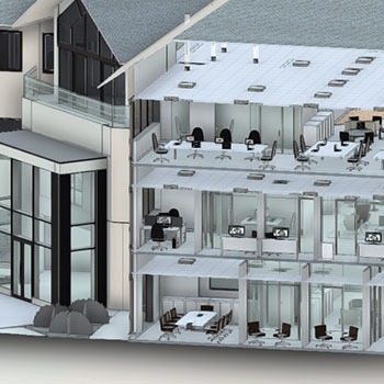
The BIM process applies to the life cycle of a project, from feasibility and design to the handover stage of as-built models. It is reliant on the creation, maintenance and understanding of a comprehensive 3D model of the subject area that clearly identifies and defines the inherent features, attributes, dimensions, nature, and condition. In order to produce such models, we suggest laser scanning methods to efficiently capture vast amounts of data that can then be extracted by the CAD team and managed through the Revit software.
This is a faster method of data capture that allows us to tailor the output to the needs of the client within the levels of specified detail.
Most projects are required to use BIM methods and outputs as part of their design, construction and delivery process. Vision offers BIM level 1 & 2 surveys designed to meet this requirement. You can read more about BIM HERE.
To find out more about the different types of services we offer or ask about our laser scanning capabilities, contact us: 01293 223435 or sales@vision.co.uk.